


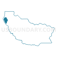
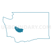
Voting District 26-214, Pierce County, Washington
About
Outline

Summary
| Unique Area Identifier | 687983 |
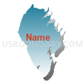
| Name | Voting District 26-214 |
| County | Pierce County |
| State | Washington |
| Area (square miles) | 24.89 |
| Land Area (square miles) | 24.62 |
| Water Area (square miles) | 0.27 |
| % of Land Area | 98.93 |
| % of Water Area | 1.07 |
| Latitude of the Internal Point | 47.23410350 |
| Longtitude of the Internal Point | -122.78022230 |
Maps

Graphs
Select a template below for downloading or customizing gragh for Voting District 26-214, Pierce County, Washington


Neighbors
Neighoring Voting District (by Name) Neighboring Voting District on the Map
- Voting District 26-213, Pierce County, WA
- Water: Carr Inlet, Pierce County, WA
- Water: Case Inlet Leg 26, Pierce County, WA
- Water: Filucy Bay, Pierce County, WA
- Water: Mayo Cove, Pierce County, WA
- Water: Puget Sound Leg 26, Pierce County, WA
- Water: Van Geldern Cove, Pierce County, WA